
Rikcha:Chongqing, China ESA23338300.jpeg

Qallariy willañiqi (2126 × 2126 iñu; willañiqip chhikan kaynin: 1,56 MB; MIME laya: image/jpeg)
| Kay willañiqiqa kay uranpi yapa willasqakunapas Wikimedia Commons sutiyuq chawpi midya hallch'amantam ch'aqtasqa. | Commons nisqapi ch'uyanchana p'anqaman |
Pisichay
| T'iktuna |
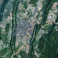
English: Chongqing, the largest municipality in China, is featured in this Copernicus Sentinel-2 image. Covering an area of over 80 000 sq km, around the size of Austria, Chongqing is located in southwest-central China. Chongqing covers a large area crisscrossed by rivers and mountains. These are the Daba Mountains in the north, the Wu Mountains in the east, the Wuling Mountains in the southeast and the Dalou Mountains in the south. The city of Chongqing, one of the most important economic centres in China, is known as a ‘mountain city’ owing to its rugged terrain and steep gorges. Chongqing is a major manufacturing and transportation centre, and has become the biggest automobile manufacturing base in China. The city lies at the confluence of the Yangtze and Jialing rivers, where the clashing colours of the rivers meet. The Yangtze river is visible in brown in the right of the image, while the green waters of the Jialing can be seen in the left. The rivers make Chongqing China's biggest port city in the southwest region. With a length of 6300 km, the Yangtze is the longest river in both China and Asia and the third longest river in the world. The Jialing River, rises in the Qin Mountains, and joins the Yangtze after a course of around 1190 km. Copernicus Sentinel-2 is a two-satellite mission. Each satellite carries a high-resolution camera that images Earth’s surface in 13 spectral bands. The mission is mostly used to track changes in the way land is being used and to monitor the health of our vegetation. This image is also featured on the Earth from Space video programme. |
| P'unchaw | 11 ñiqin hunyupi 2021 watapi (fecha de carga) |
| Pukyu | Chongqing, China |
| Ruraq | European Space Agency |
| Huk musuqchasqakuna |
|
| Activity | Observing the Earth |
| Mission | Sentinel-2 |
| Set | Earth observation image of the week |
| System | Copernicus |
Saqillaspa

|
Esta imagen contiene datos que provienen de un satélite del Programa Copérnico, como Sentinel-1, Sentinel 2 o Sentinel-3. Se require atribución cuando se utilice esta imagen.
Ruraqpa sutinta willay: Contiene datos modificados de Copernicus Sentinel 2018
El uso de datos Sentinel del Programa Cópernico está regulado por la legislación europea: Reglamento Delegado (UE) No 1159/2013 de la Comisión y el Reglamento (UE) No 377/2014. Los pasajes relevantes son:
Se permitirá el acceso gratuito a los datos dedicados del GMES y a la información de servicio del GMES a través de las plataformas de difusión del GMES [...].
Se dará acceso a los datos dedicados del GMES y a la información de servicio del GMES a los efectos que se detallan a continuación, siempre y cuando sean lícitos:
Los datos dedicados del GMES y la información de servicio del GMES podrán utilizarse en todo el mundo sin limitación de tiempo.
Los datos dedicados del GMES y la información de servicio del GMES se facilitarán a los usuarios sin ninguna garantía explícita o implícita, incluyendo lo tocante a la calidad y la idoneidad para cualesquiera fines. |
This media was created by the European Space Agency (ESA).
Where expressly so stated, images or videos are covered by the Creative Commons Attribution-ShareAlike 3.0 IGO (CC BY-SA 3.0 IGO) licence, ESA being an Intergovernmental Organisation (IGO), as defined by the CC BY-SA 3.0 IGO licence. The user is allowed under the terms and conditions of the CC BY-SA 3.0 IGO license to Reproduce, Distribute and Publicly Perform the ESA images and videos released under CC BY-SA 3.0 IGO licence and the Adaptations thereof, without further explicit permission being necessary, for as long as the user complies with the conditions and restrictions set forth in the CC BY-SA 3.0 IGO licence, these including that:
See the ESA Creative Commons copyright notice for complete information, and this article for additional details.
|
 | |
Este archivo se encuentra bajo la licencia Creative Commons Atribución Compartir-Igual 3.0 IGO. Ruraqpa sutinta willay: ESA, CC BY-SA IGO 3.0
| ||
Willañiqip wiñay kawsaynin
P'unchaw/pacha nisqapi ñit'iy chaypacha willañiqi kachkasqata qhawanaykipaq.
| P'unchaw/Pacha | Uchuylla rikchacha | Chhikanyachikuqkuna | Ruraq | Willapuy | |
|---|---|---|---|---|---|
| kunan | 10:28 11 hun 2021 | | 2126 × 2126 (1,56 MB) | OptimusPrimeBot | #Spacemedia - Upload of https://www.esa.int/var/esa/storage/images/esa_multimedia/images/2021/06/chongqing_china/23338289-1-eng-GB/Chongqing_China.jpg via Commons:Spacemedia |
Maypim willañiqita llamk'achinku
Kay rikchamanqa kay qatiq p'anqam t'inkimun:
Mayqin wikikunapi willañiqita llamk'achinku
Kay wakin wikikunam willañiqitaqa llamk'achinku:
- arz.wikipedia.org-pi kaykunapi llamk'achinku
- ast.wikipedia.org-pi kaykunapi llamk'achinku
- ba.wikipedia.org-pi kaykunapi llamk'achinku
- ca.wikipedia.org-pi kaykunapi llamk'achinku
- ce.wikipedia.org-pi kaykunapi llamk'achinku
- cy.wikipedia.org-pi kaykunapi llamk'achinku
- de.wikivoyage.org-pi kaykunapi llamk'achinku
- el.wikipedia.org-pi kaykunapi llamk'achinku
- en.wikivoyage.org-pi kaykunapi llamk'achinku
- eo.wikinews.org-pi kaykunapi llamk'achinku
- fr.wikivoyage.org-pi kaykunapi llamk'achinku
- ga.wikipedia.org-pi kaykunapi llamk'achinku
- gl.wikipedia.org-pi kaykunapi llamk'achinku
- ha.wikipedia.org-pi kaykunapi llamk'achinku
- he.wikivoyage.org-pi kaykunapi llamk'achinku
- hy.wikipedia.org-pi kaykunapi llamk'achinku
- ia.wikipedia.org-pi kaykunapi llamk'achinku
- incubator.wikimedia.org-pi kaykunapi llamk'achinku
- it.wikivoyage.org-pi kaykunapi llamk'achinku
- mhr.wikipedia.org-pi kaykunapi llamk'achinku
- no.wikipedia.org-pi kaykunapi llamk'achinku
- ru.wikinews.org-pi kaykunapi llamk'achinku
- sr.wikipedia.org-pi kaykunapi llamk'achinku
- tt.wikipedia.org-pi kaykunapi llamk'achinku
- vec.wikipedia.org-pi kaykunapi llamk'achinku
- www.wikidata.org-pi kaykunapi llamk'achinku