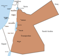
Rikcha:PalestineAndTransjordan.png

Contenido de la página no disponible en otros idiomas.
Wikipediamanta

PalestineAndTransjordan.png(636 × 599 iñu; willañiqip chhikan kaynin: 65 kB; MIME laya: image/png)

Kay willañiqiqa kay uranpi yapa willasqakunapas Wikimedia Commons sutiyuq chawpi midya hallch'amantam ch'aqtasqa. Commons nisqapi willañiqi ch'uyanchana p'anqaman riy Commons nisqapi ch'uyanchana p'anqaman
File:PalestineAndTransjordan.svg es una versión vectorial de este archivo. Debería usarse esa versión en lugar de este archivo PNG, cuando sea mejor.

File:PalestineAndTransjordan.png → File:PalestineAndTransjordan.svg

Para más información, lee Ayuda:SVG.

En otros idiomas
Alemannisch  Bahasa Indonesia  Bahasa Melayu  British English  català  čeština  dansk  Deutsch  eesti  English  español  Esperanto  euskara  français  Frysk  galego  hrvatski  Ido  italiano  lietuvių  magyar  Nederlands  norsk bokmål  norsk nynorsk  occitan  Plattdüütsch  polski  português  português do Brasil  română  Scots  sicilianu  slovenčina  slovenščina  suomi  svenska  Tiếng Việt  Türkçe  vèneto  Ελληνικά  беларуская (тарашкевіца)  български  македонски  нохчийн  русский  српски / srpski  татарча/tatarça  українська  ქართული  հայերեն  বাংলা  தமிழ்  മലയാളം  ไทย  한국어  日本語  简体中文  繁體中文  עברית  العربية  فارسی  +/−
Nueva imagen SVG

T'iktuna
English: Map of the British Mandate of Palestine and Transjordan.
Note: Wasserstein, Bernard (2004). Israel and Palestine: Why They Fight and Can They Stop?, pp. 105–106."Palestine, therefore, was not partitioned in 1921–1922. Transjordan was not excised but, on the contrary, added to the mandatory area. Zionism was barred from seeking to expand there – but the Balfour Declaration had never previously applied to the area east of the Jordan. Why is this important? Because the myth of Palestine's 'first partition' has become part of the concept of 'Greater Israel' and of the ideology of Jabotinsky's Revisionist movement."
Pukyu

Originally uploaded on the English Wiki (all linking to en.wikipedia):

08:13, 8 June 2005 Doron (Talk / contribs) uploaded "Image:PalestineAndTransjordan.png"
Ruraq User:Doron
Saqillay
(Kay willañiqita musuqmanta llamk'achiy)
GNU head Saqillayqa huñikusqam kay atiqllata iskaychaypaq, mast'ariypaq icha wakinchaypaq kay saqillaypa phatankunakama: GNU Free Documentation License, musuqchasqa 1.2 icha ima qhipaqnin kaq musuqchasqapas Free Software Foundation nisqap uyaychasqan; mana "mana wakinchana rakinakuna", "ñawpaq qata p'anqa" icha "qhipaq qata p'anqa" nisqa qillqayuq. Saqillaypa iskaychasqanqa GNU Free Documentation License nisqa rakipi ch'aqtasqam.
w:es:Creative Commons
Ruraqpa sutinta willay Kay hinallataq rakinakuy
Kay willañiqiqa Creative Commons nisqap kay hinallataq rakinakuy 3.0 mana apasqa saqillayninwanmi saqillasqa.
Qispilla rurarillay:
  • rakinakuy – iskaychay, mast'ariy, maymanpas kachay kay rurasqata
  • musuqmanta chaqruy – rurasqata tupayay
Kay phatakuna tukuptinqa:
  • Ruraqpa sutinta willay – Kay rurasqataqa ruraqninpa icha saqillaqninpa sut'ichasqan hina unanchanaykim (ichataq amapuni kay hinachu, pay q'imisunkiman icha rurayniykita q'iminman rikch'akunman).
  • Kay hinallataq rakinakuy – Kay rurasqata hukchaspayki wakinchaspayki icha paymanta musuqta ruraspaykiqa, musuq rurasqaykita kikillan icha payman kaqlla saqillayllawanmi mast'arinkiman.
Kay saqillay unanchachaqa GFDL saqillay musuqchaywanmi kay willañiqiman yapasqa.
Huk musuqchasqakuna Image:BritishMandatePalestine1920.png

Leyendas

Añade una explicación corta acerca de lo que representa este archivo

Elementos representados en este archivo

representa a Español Simi

Willañiqip wiñay kawsaynin

P'unchaw/pacha nisqapi ñit'iy chaypacha willañiqi kachkasqata qhawanaykipaq.

P'unchaw/PachaUchuylla rikchachaChhikanyachikuqkunaRuraqWillapuy
kunan15:17 22 mar 201915:17 22 mar 2019-pa musuqchasqanmanta uchuylla rikchacha636 × 599 (65 kB)Claude ZygielThis file in clearly definite as "Map of the British Mandate of Palestine '''and''' Transjordan" and used for the both territories
12:01 24 ukt 201712:01 24 ukt 2017-pa musuqchasqanmanta uchuylla rikchacha636 × 599 (61 kB)Nicola RomaniReverted to version as of 11:02, 22 April 2016 (UTC)
17:04 30 awu 201717:04 30 awu 2017-pa musuqchasqanmanta uchuylla rikchacha675 × 542 (51 kB)OnceinawhileConverted into new svg - this is the png version
16:07 19 ukt 201616:07 19 ukt 2016-pa musuqchasqanmanta uchuylla rikchacha636 × 599 (65 kB)Claude ZygielThis file in clearly definite as "Map of the British Mandate of Palestine '''and''' Transjordan" and used for the both territories.
11:02 22 awr 201611:02 22 awr 2016-pa musuqchasqanmanta uchuylla rikchacha636 × 599 (61 kB)Makeandtossoops
11:01 22 awr 201611:01 22 awr 2016-pa musuqchasqanmanta uchuylla rikchacha636 × 599 (61 kB)MakeandtossRemoved Mandatory Palestine since picture is used to refer to only the emirate
15:49 4 dis 201115:49 4 dis 2011-pa musuqchasqanmanta uchuylla rikchacha636 × 599 (66 kB)Wickey-nlthicker lining around lake
21:43 3 dis 201121:43 3 dis 2011-pa musuqchasqanmanta uchuylla rikchacha636 × 599 (66 kB)Wickey-nlFixed border
15:29 29 ini 201115:29 29 ini 2011-pa musuqchasqanmanta uchuylla rikchacha636 × 599 (77 kB)VadacFixed border of Transjordan within the Mandate of Palestine with Saudi Arabia per the present border having been drawn in 1965 as seen here.
11:29 24 phi 200611:29 24 phi 2006-pa musuqchasqanmanta uchuylla rikchacha636 × 599 (89 kB)Lohen11Palestine from:

Kay rikchamanqa kay qatiq p'anqam t'inkimun:

Mayqin wikikunapi willañiqita llamk'achinku

Kay wakin wikikunam willañiqitaqa llamk'achinku:

Qhaway mayqin wikikunapim willañiqita llamk'achinku.

Metadata

"https://qu.wikipedia.org/wiki/Rikcha:PalestineAndTransjordan.png" p'anqamanta chaskisqa (Wikipedia, Qhichwa / Quechua)