
Rikcha:Canterbury UK locator map.svg

Tamaño de esta previsualización PNG del archivo SVG: 800 × 561 iñu. Huk huyakukuna: 320 × 225 iñu | 640 × 449 iñu | 1024 × 719 iñu | 1280 × 898 iñu | 2560 × 1796 iñu | 1425 × 1000 iñu.
Qallariy willañiqi (SVG willañiqi, rimasqakama 1425 × 1000 iñuyuq, willañiqip chhikan kaynin: 1,18 MB)
| Kay willañiqiqa kay uranpi yapa willasqakunapas Wikimedia Commons sutiyuq chawpi midya hallch'amantam ch'aqtasqa. | Commons nisqapi ch'uyanchana p'anqaman |
| T'iktuna |
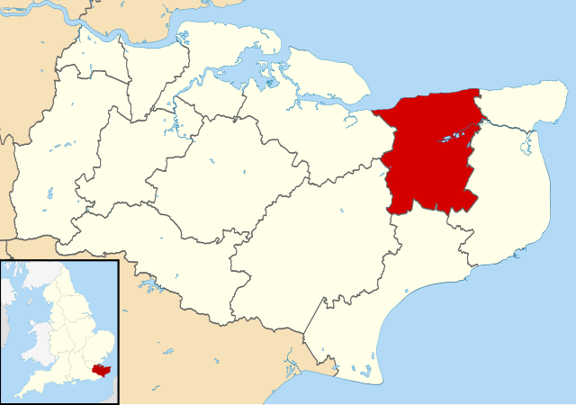
Map of Kent, UK with Canterbury highlighted. Equirectangular map projection on WGS 84 datum, with N/S stretched 160% |
| P'unchaw | |
| Pukyu |
|
| Ruraq | Nilfanion, created using Ordnance Survey data |
| Saqillay (Kay willañiqita musuqmanta llamk'achiy) |
Kay willañiqiqa Creative Commons nisqap kay hinallataq rakinakuy 3.0 mana apasqa saqillayninwanmi saqillasqa. Ruraqpa sutinta willay: Contains Ordnance Survey data © Crown copyright and database right
|
Willañiqip wiñay kawsaynin
P'unchaw/pacha nisqapi ñit'iy chaypacha willañiqi kachkasqata qhawanaykipaq.
| P'unchaw/Pacha | Uchuylla rikchacha | Chhikanyachikuqkuna | Ruraq | Willapuy | |
|---|---|---|---|---|---|
| kunan | 09:06 2 awu 2011 | | 1425 × 1000 (1,18 MB) | Nilfanion | {{Information |Description=Map of Kent, UK with Canterbury highlighted. Equirectangular map projection on WGS 84 datum, with N/S stretched 160% |Source=Ordnance Survey [https://www.ordnancesurvey. |
Maypim willañiqita llamk'achinku
Kay rikchamanqa kay qatiq p'anqam t'inkimun:
Mayqin wikikunapi willañiqita llamk'achinku
Kay wakin wikikunam willañiqitaqa llamk'achinku:
- ar.wikipedia.org-pi kaykunapi llamk'achinku
- azb.wikipedia.org-pi kaykunapi llamk'achinku
- br.wikipedia.org-pi kaykunapi llamk'achinku
- cy.wikipedia.org-pi kaykunapi llamk'achinku
- en.wikipedia.org-pi kaykunapi llamk'achinku
- Canterbury
- Herne Bay
- Whitstable
- Fordwich
- City of Canterbury
- Reculver
- Sturry
- Westbere
- Chartham
- Adisham
- Harbledown
- Bishopsbourne
- Herne and Broomfield
- Blean
- Barham, Kent
- Bekesbourne-with-Patrixbourne
- Upper Harbledown
- Marshside, Kent
- Chislet
- Womenswold
- Chestfield
- Hoath
- Template:Canterbury
- Bekesbourne
- Bridge, Kent
- Hackington
- Herne, Kent
- Hersden
- Patrixbourne
- Ickham and Well
- Kingston, Kent
- Littlebourne
- Lower Hardres
- Upper Hardres
- Petham
- Yorkletts
- Tankerton
- Wickhambreaux
- Thanington
- Wincheap
- Swalecliffe
- Tyler Hill, Kent
- Beltinge
- Waltham, Kent
- Rough Common
- Broad Oak, Kent
Qhaway mayqin wikikunapim willañiqita llamk'achinku.