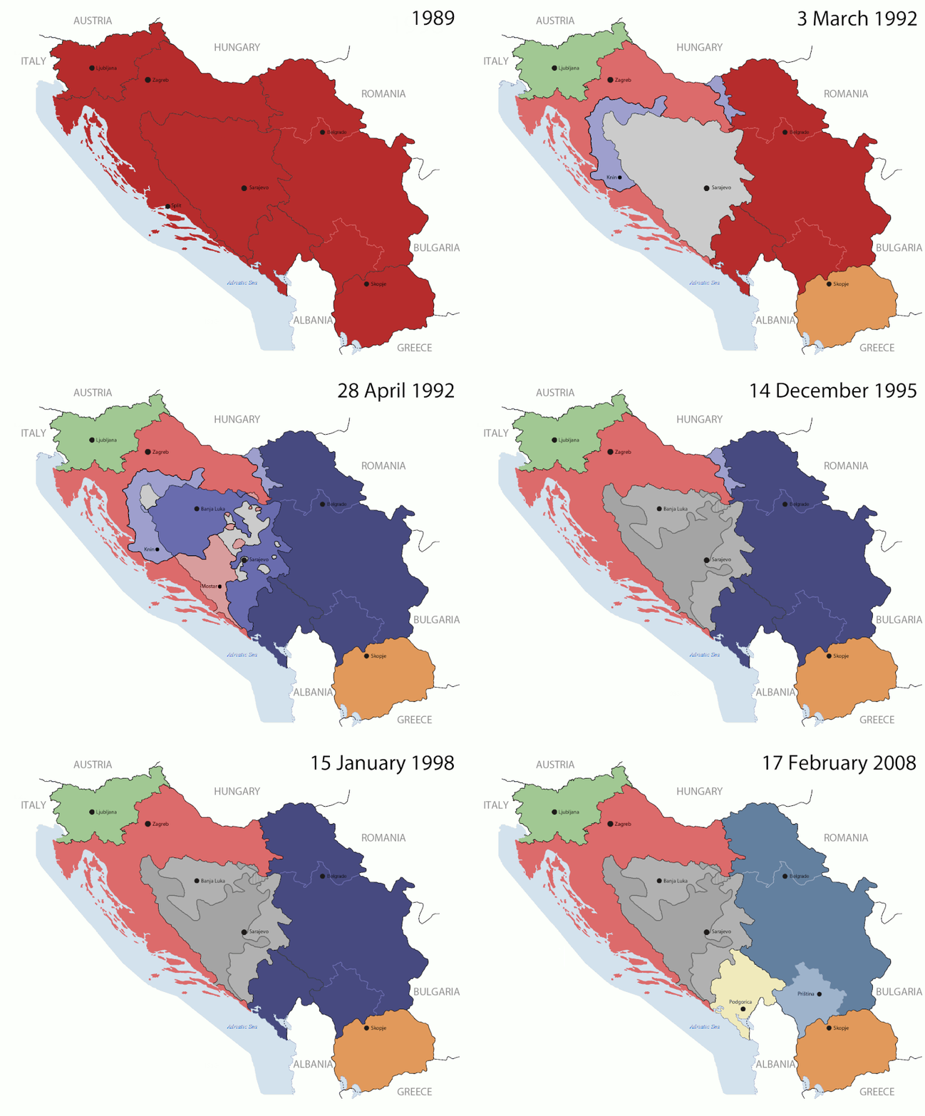
Rikcha:Breakup of Yugoslavia.gif
Contenido de la página no disponible en otros idiomas.
Wikipediamanta

Qallariy willañiqi(1545 × 1242 iñu; willañiqip chhikan kaynin: 187 kB; MIME laya: image/gif, muyupayachisqa, 14 inchukuna, 44s)

Kay willañiqiqa kay uranpi yapa willasqakunapas Wikimedia Commons sutiyuq chawpi midya hallch'amantam ch'aqtasqa. Commons nisqapi willañiqi ch'uyanchana p'anqaman riy Commons nisqapi ch'uyanchana p'anqaman
Esta imagen volverse a crear usando gráficos vectoriales como un archivo SVG. Esto proporciona muchas ventajas, véase Commons:Media for cleanup (en inglés) para más información. Si ya hay una versión SVG de esta imagen disponible, por favor súbala a Commons. Tras subirla, reemplace esta plantilla con la plantilla {{vector version available|nuevo nombre de imagen.svg}} en esta imagen. Se recomienda nombrar el archivo SVG "Breakup of Yugoslavia.svg" - entonces la plantilla Vector version available (o Vva) no necesita el parámetro nuevo nombre de imagen.

Pisichay

Key:

Yugoslavia (1943–1992) SFR Yugoslavia
Croatia (1991–present) Croatia
Herzeg-Bosnia (1992–1994)
UNTAES (1996–1998)
Federal Republic of Yugoslavia / Serbia and Montenegro (1992–2006) Serbia and Montenegro
Republika Srpska (1992–present) Republika Srpska
Serbian Krajina (1991–1995/96)
Republic of Bosnia and Herzegovina (1992–1995)
Bosnia and Herzegovina (1998–present) Bosnia and Herzegovina
Western Bosnia (1993–1995)
Serbia (2006–present) Serbia
Kosovo (under UNMIK control 1999–present; declaration of independence 2008) Kosovo
Montenegro (2006–present) Montenegro
Macedonia (1991–present) Macedonia
Slovenia (1991–present) Slovenia


T'iktuna

This is an animated GIF that shows the stages of the breakup of the SFR Yugoslavia in the 90's and 2000's. The map based off Morwen's map of the divisions of the SFRY, Which is licensed by the GFDL. The source for the dates of independence is the CIA World Factbook. These maps do not now show the Inter-Entity Boundary Line (IEBL) and/or the entities that are separated by it. The IEBL has been drawn based on this CIA map; the Brčko District has been drawn based on Image:BH municipality location.gif, by user:Ante Perkovic. I might add them in the future.

Since the original map was GFDL, this image is as well.

A map depicting Kosovo's final status is ready once it takes effect.


Changelog for versions 2/3:

Here are some changes in this new build of the map:

  • The Kosovo boundary has been given a shade of red instead of the previous UN blue since they are a province of Serbia under UNIMIK control.
  • Montenegro's color has been changed to a golden shade close to what's on the flag.
  • The IEBL and the Brčko District has been redrawn because I deleted the original map; the color for the Republika Srpska is lighter.
  • The dates are at the top left hand corner of the map instead of the bottom.
  • I have taken a new approach as to the boundaries. Each part of Yugoslavia now shows the boundary on the maps starting the year they broke away. I feel this change helps readers understand the breakup better.
  • The SFRY and the FRY are in different shades since the FRY was never accepted as the successor to the former by the UN.
  • The colors for the entities of BiH have been removed as to not confuse people into thinking that they are independent states. What remains is the IEBL with both entities in green.
  • The Kosovo boundary is finally in hash marks!
  • The Brčko District has been removed. The sale is too small to show accurately.

Changelog for version 4:

  • The map is larger!
  • The image has been rebuilt to include the eastern part of FYR Macedonia.
  • The image has been updated to take in Kosovo's new status.
  • The IEBL is now a darker line.
  • Montenegro, Kosovo, and FRY/SCG/Serbia have new colors!

Changelog for version 5:

  • Rebuilt
  • Larger map: size of base image
  • Accurate Inter-Entity Boundary Line
P'unchaw 24 July 2006 (orginal upload date)
Pukyu Made by Hoshie; see above for more details on sources.
Ruraq Hoshie
Huk musuqchasqakuna

Saqillaspa

GNU head Saqillayqa huñikusqam kay atiqllata iskaychaypaq, mast'ariypaq icha wakinchaypaq kay saqillaypa phatankunakama: GNU Free Documentation License, musuqchasqa 1.2 icha ima qhipaqnin kaq musuqchasqapas Free Software Foundation nisqap uyaychasqan; mana "mana wakinchana rakinakuna", "ñawpaq qata p'anqa" icha "qhipaq qata p'anqa" nisqa qillqayuq. Saqillaypa iskaychasqanqa GNU Free Documentation License nisqa rakipi ch'aqtasqam.
w:es:Creative Commons
Ruraqpa sutinta willay Kay hinallataq rakinakuy
Kay willañiqiqa Creative Commons nisqap kay hinallataq rakinakuy 3.0 mana apasqa saqillayninwanmi saqillasqa.
Qispilla rurarillay:
  • rakinakuy – iskaychay, mast'ariy, maymanpas kachay kay rurasqata
  • musuqmanta chaqruy – rurasqata tupayay
Kay phatakuna tukuptinqa:
  • Ruraqpa sutinta willay – Kay rurasqataqa ruraqninpa icha saqillaqninpa sut'ichasqan hina unanchanaykim (ichataq amapuni kay hinachu, pay q'imisunkiman icha rurayniykita q'iminman rikch'akunman).
  • Kay hinallataq rakinakuy – Kay rurasqata hukchaspayki wakinchaspayki icha paymanta musuqta ruraspaykiqa, musuq rurasqaykita kikillan icha payman kaqlla saqillayllawanmi mast'arinkiman.
Kay saqillay unanchachaqa GFDL saqillay musuqchaywanmi kay willañiqiman yapasqa.

Leyendas

Añade una explicación corta acerca de lo que representa este archivo

Elementos representados en este archivo

representa a Español Simi

creador Español Simi

Algún valor sin elemento de Wikidata

tipo de archivo Español Simi

image/gif

suma de verificación Español Simi

05ca2aefea8406b809968643552d5095c847a42f

método de determinación Español Simi: SHA-1 Español Simi

tamaño de los datos Español Simi

191 625 byte

duración Español Simi

44 sikundu

altura Español Simi

1242 píxel

ancho Español Simi

1545 píxel

Willañiqip wiñay kawsaynin

P'unchaw/pacha nisqapi ñit'iy chaypacha willañiqi kachkasqata qhawanaykipaq.

(Qhipaqkuna | Ñawpaqkuna) Qhaway (aswan musuq 10) () (10 | 20 | 50 | 100 | 250 | 500).
P'unchaw/PachaUchuylla rikchachaChhikanyachikuqkunaRuraqWillapuy
kunan07:40 17 hul 201607:40 17 hul 2016-pa musuqchasqanmanta uchuylla rikchacha1545 × 1242 (187 kB)מפתח-רשימהReverted to version as of 17:22, 21 August 2015 (UTC)
17:22 21 awu 201517:22 21 awu 2015-pa musuqchasqanmanta uchuylla rikchacha1463 × 1158 (1,81 MB)BraganzaReverted to version as of 03:57, 19 January 2010
17:22 21 awu 201517:22 21 awu 2015-pa musuqchasqanmanta uchuylla rikchacha1545 × 1242 (187 kB)BraganzaReverted to version as of 01:02, 19 December 2011
17:15 21 awu 201517:15 21 awu 2015-pa musuqchasqanmanta uchuylla rikchacha120 × 95 (3 kB)Braganza03:57, 19. Jan. 2010
01:02 19 dis 201101:02 19 dis 2011-pa musuqchasqanmanta uchuylla rikchacha1545 × 1242 (187 kB)DIREKTORAdded details
18:09 27 hul 201118:09 27 hul 2011-pa musuqchasqanmanta uchuylla rikchacha1545 × 1242 (170 kB)DIREKTORSmall fixes
17:28 27 hul 201117:28 27 hul 2011-pa musuqchasqanmanta uchuylla rikchacha1545 × 1242 (171 kB)DIREKTORAdded UNMIK
16:38 27 hul 201116:38 27 hul 2011-pa musuqchasqanmanta uchuylla rikchacha1545 × 1242 (165 kB)DIREKTORDates for the last two frames.
12:10 27 hul 201112:10 27 hul 2011-pa musuqchasqanmanta uchuylla rikchacha1545 × 1242 (149 kB)DIREKTORLighter shade for country names
16:59 26 hul 201116:59 26 hul 2011-pa musuqchasqanmanta uchuylla rikchacha1545 × 1242 (170 kB)DIREKTORHigher res plus details
(Qhipaqkuna | Ñawpaqkuna) Qhaway (aswan musuq 10) () (10 | 20 | 50 | 100 | 250 | 500).

Kay rikchamanqa kay qatiq p'anqam t'inkimun:

Mayqin wikikunapi willañiqita llamk'achinku

Kay wakin wikikunam willañiqitaqa llamk'achinku:

Qhaway mayqin wikikunapim willañiqita llamk'achinku.

Metadata

"https://qu.wikipedia.org/wiki/Rikcha:Breakup_of_Yugoslavia.gif" p'anqamanta chaskisqa (Wikipedia, Qhichwa / Quechua)